Every picture tells a story
A BRAND new book from Clear Vue Publishing Partnership is always cause to celebrate. In the past the company has published beautifully detailed and lavish limited editions such as Festung Guernsey, The King’s Survey of the Channel Islands 1680 and The Guernsey Lilly.
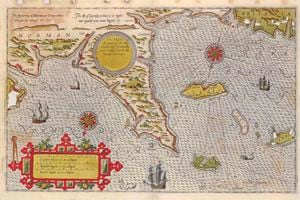
Its latest, which is launched this evening, is A Cartographic History of the Channel Islands.
‘I’ve been thinking about doing this for a long time,’ said Martin Morgan, founder of Clear Vue. ‘I received permission and have been working closely with the Priaulx Library in Guernsey, who have a magnificent collection of Channel Island maps, and with the Jersey Archives’ Clarke Collection, which is unrivalled for early maps.
‘The plan is to tell the story of our islands entirely in maps – from the very earliest to the very latest, creating a unique look at our history.’
Martin, the son of a former Advisory and Finance Committee president, Conseiller Peter Morgan, has always had a deep interest in early maps.
‘We know that neolithic man knew where the Channel Islands were, and we also know that the Romans knew where we were, but when did the world know where we were? The Channel Islands are very small, but are disproportionately important to the rest of the world.’
Martin’s research goes back as far as Claudius Ptolemy (c. AD 90-168), whom he calls ‘the father of cartography’.
‘None of his maps exist, just a list of coordinates,’ explains Martin.
He also investigated whether Guernsey was originally called Sarnia or Lisia.
‘In the Antonine Itinerary, which covered the whole of Roman occupied territory, possibly early in the third century AD Jersey was known as Caesarea and Guernsey as Sarnia. Guernsey was also named Lisia. Charles Parkinson wrote a very good book called Lisia – Vortigern’s Island.’
Martin believes that maps are ingrained within us.
‘When people are asked “What does your island look like?” almost certainly what you imagine is a map. Though not everyone’s idea might be accurate.’
During his research he unearthed some real gems which held fascinating insights into our growing island.
‘De Magnac’s maps of the towns of St Peter Port and St Helier are among the first to be recorded and he shows different carriageways across the Braye du Valle. I also managed to find de Saumarez’s map of Les Casquets with a man o’ war being wrecked and a tribute to the drowned.
‘Also the Nicholas Dobree maps are extremely good and instrumental to the trade between the Channel Islands and the rest of the world.’
Martin is planning to print the book in autumn 2018.
‘You start off and think, “Is this a good idea? These things are quite beautiful – can we do it?” This book is half a metre high and we’re trying to get as much in full size and all of it in full colour and enlarge smaller maps. This rarely happens.’
The beauty of the images inside will be reflected on the book’s cover, which will be quarter-bound in leather and feature a specially designed cover and end papers using a map design which will be marbled over. Tests have been carried out recently by Jemma Lewis Marbling and Design.
As Clear Vue Publishing Partnership was founded in 2001 in order to publish the first ever edition of the manuscript known as Festung Guernsey, it’s fitting that this is echoed in the new book.
‘With the kind permission of the Guernsey Royal Court, we have created a new map of the island by combining all 13 coastal maps from the second volume of Festung,’ explained Martin.
‘I’m not yet an expert on maps,’ he added, ‘but I’m a huge, huge fan. They are so beautiful and it’s so fascinating for one to see his or her favourite bit of the island.’
For more information about A Cartographic History of the Channel Islands please contact Martin at
mm@extraordinaryeditions.com or visit www.clearvuepublishing.com