Fortification of Common meant family trips were no picnic
IN THE early decades of the 20th century, L’Ancresse Common was a lovely place for Sunday picnics – be they small family affairs or larger Sunday school outings and the like.
But when these aerial shots were taken by an RAF reconnaissance aircraft in February 1945 there was certainly no picnicking going on and there would not be for a long, long while.
The Common was a mess.
Where pre 1939 the only structures came in the form of picturesque granite loophole towers, a golf club building and a dolmen, by the end of the war the Common was littered with ugly concrete bunkers, huts, flak guns, searchlights, trenches and a whole lot of barbed wire.
And, of course, a spanking new concrete anti-tank wall which 80 years later is creating a bit of a political stir.
Festung Guernsey’s Paul Bourgaize and Pierre Renier have studied the aerial shots kindly provided by Digimap to LOOKback and between them made sense of the scrapes, scars, lines and other features on the shots.
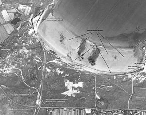
The photographs show how extensive the German operations were at La Varde where today the Millennium Stone stands.
Then, this hillock was surrounded by barbed wire and the Germans did their best to camouflage their extensive concrete workings by removing huge amounts of turf from the middle of the common.
That white scarring is clearly visible in the picture, as is the line of the 90cm-gauge railway that ran almost parallel with the main L’Ancresse road to the beach and continued to the west side of Pembroke, where a large area of bay was reclaimed with the construction of the wall.
Today that same area is a car park and turning area for buses.
There is no semblance of any golf green or teebox, yet the occupiers did name one area close to the golf club as Wn. Golfwerk.
It operated as a small resistance nest protecting the west side of the bay.
Digimap Ltd has acquired 10,000 images taken by RAF reconnaissance aircraft in February 1945 which show our island in the final throes of German rule.
The 1945 imagery is now available as a seamless aerial photo of the island which makes it easy to navigate to sites of interest and compare with present-day mapping.
Visit the Digimap website and click on the aerial view of Fort George as it was back then.
Islanders can also examine some of those remarkably revealing aerial shots of Guernsey 73 years ago via an outdoor exhibition of Second World War aerial photography in the grounds of the Priaulx Library. The pictures are on show until 8 June and the aerial data provides a unique insight into the defences constructed during the Occupation of the Bailiwick.