Storm Darcy to bring snow, ice and rain to parts of Britain
Daytime temperatures will stay in low single figures for much of the country, with some places staying below freezing, the Met Office said.

Bouts of “significant disruptive snowfall” are set to hit the South East, with Storm Darcy also set to bring gale force winds to parts of England, forecasters said.
Easterly winds from the Ukraine and Black Sea area on Sunday will bring an intense chill but the air will not be as bitingly cold as it was with the Beast from the East in 2018, the Met Office said.
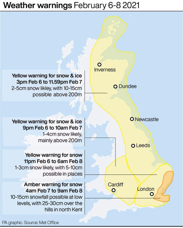
Amber weather warnings of snow which suggest there could be widespread travel disruption in parts of London, the east and south east of England have been issued by the Met Office for Sunday and Monday morning.
Warnings for rain, snow and ice are also in place on Saturday as snow showers could affect many northern and eastern parts of the UK.

Various warnings for snow and ice across the eastern length of Britain are in place until Wednesday.
Heavy disruptive snow is expected in south-east England along with 40-50mph wind gusts that could cause snowdrifts from Sunday through to Monday morning, according to the Met Office.
Meteorologist Sarah Kent said: “There will be significant disruptive snowfall across the South East.
“Within this area, there is a small chance particularly over the Downs of Kent and the North Downs that you could see 25-30cm of snow.
“It is a small chance but the threat is there, up to a foot of snow potentially combined with extremely strong easterly winds. Even inland in that area, gusting could be 45mph and higher than that on the coasts.
“Sadly there will be people who have to make journeys for the emergency services and there are still lorries that have to go to the ports. It is going to be really disruptive.
“With that sort of snowfall, you would expect some roads to be closed or blocked by the drifting snow, and long delays or some cancellations of public transport.”
She added: “We are only looking at significant snowfall tomorrow across the south east of England, so while we have these cold easterly winds it is not as widespread as the Beast from the East in 2018.
“Tomorrow’s events – the easterly winds originate from Ukraine and the Black Sea – eastern Europe – the air will be cold but it will not be as bitingly cold as it was back in 2018.”
The Met Office said the Dutch have named the low-pressure system that will bring strong winds and widespread snow to south-east England on Sunday as Storm Darcy.
Places affected by the amber warning and expected to be hit by Darcy include Norfolk, Suffolk, Essex and Kent.
Roads may become blocked by deep snow, with the possibility of stranded vehicles and passengers.
Cold air emanating from Russia and Eastern Europe will move across the UK over the coming days, bringing “significant” snow to parts of Eastern England and Scotland, forecasters said.
Daytime temperatures will stay in low single figures for much of the country, with some places staying below freezing and the bitter winds making it feel even colder.
Public Health England (PHE) has issued a cold weather alert for the whole of England from Saturday through to Wednesday.
Dr Owen Landeg, of PHE, said: “Cold weather isn’t just uncomfortable, it can have a serious impact on health.
“For older people and those with heart and lung problems, it can increase the risks of heart attacks, strokes and chest infections.
“So it’s really crucial at this time, especially ahead of a potentially very cold snap, to remember to check on frail or older neighbours or relatives, especially those living alone or who have serious illnesses.”


