Temperature plummets as new snow warnings issued
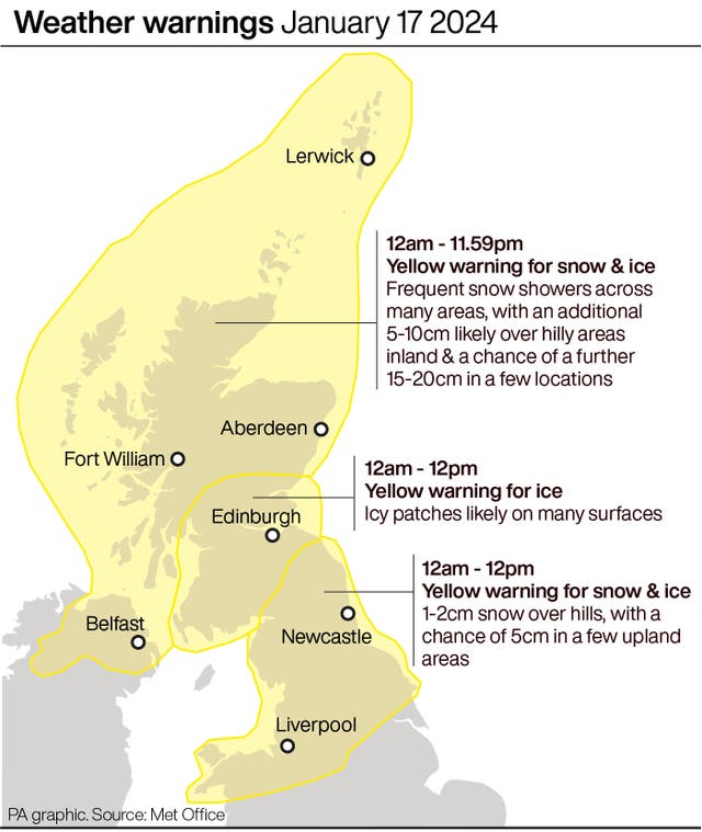
Yellow weather warnings for snow and ice are in place across Scotland, much of northern England and parts of North Wales until Thursday.

Fresh warnings have been issued for snow in the UK after temperatures dropped to the coldest of the winter so far.
According to provisional recordings by the Met Office, the mercury fell to minus 14C in Dalwhinnie in Scotland on Tuesday night, reportedly the lowest January temperature in Britain since 2019.
Forecasters had predicted some snow-covered parts of Scotland could reach minus 15C overnight, which would have been the coldest January night for 14 years, when minus 22.3C was recorded in 2010.
The Met Office has issued amber warnings for snow between 3pm on Wednesday and 6pm on Thursday in north-west Scotland and the Northern Isles, meaning road delays are likely and some vehicles could be stranded.
The forecaster said some areas could see an extra 15 to 20cm of snow, meaning power cuts are likely and more remote communities are at risk of being cut off.
It comes after the Met Office said more than 40cm of snow may fall on high ground in north-west Scotland by the end of Friday.
Tuesday night did mark the coldest night this winter so far, beating the minus 12.5C daily minimum temperature recorded at Altnaharra in the Scottish Highlands on December 3.
Freezing temperatures and snow will continue for much of Britain this week because of cold Arctic air before “potentially disruptive” stormy weather lands over the weekend.
A “cold plunge of Arctic air” has moved south across the whole country over the past few days, making it 5C to 6C lower than usual for this time of year, the Met Office said.
A Met Office spokeswoman said the low temperatures are also due to how long the cold snap has lasted.
She said: “It’s due to the prolonged nature of this cold spell, it will have been lasting for quite a few days.

“The air is coming directly from the Arctic, so it is exceptionally cold air.
“It’s staying cold until Friday, and then looking further ahead into the weekend we’ve got some deep areas of low pressure pushing in, so a big change in weather type, and we could see some stormy conditions by the end of the week.
“The cold isn’t lasting right to end of the week, but we have a very different type of potentially-disruptive weather arriving.”
The weather is forecast to turn stormy on Sunday, she added.

Meanwhile, lower ground in north-west Scotland could see between five and 10cm of snow by the end of the working week.
The Met Office said on Tuesday: “There is a system skirting the south of the UK tonight and on Wednesday. This could bring a few snow flurries to the far south with a small chance of pushing slightly further north to bring more snow to southern counties.”
It said it is reviewing the situation and any new warnings could be issued at short notice.

The Government has confirmed thousands of households in England and Wales are eligible for cold weather payments.
They are made to vulnerable people, including pensioners, to help them pay for heating when the temperature dips below freezing.
The payments go to those living in an area where the average temperature is recorded as, or forecast to be, 0C or below over seven consecutive days.
Payments will be made to homes across Cumbria, Oxfordshire, Yorkshire, Northumberland, Norfolk, Staffordshire and Powys in Wales.

More than 100 schools were closed in Scotland on Tuesday, while drivers faced difficult conditions thanks to the wintry weather across north-west England, including in Merseyside, Cheshire and Cumbria.
National Rail warned the wintry weather could affect train journeys all week, with services between Edinburgh/ Glasgow Queen Street and Inverness running to an altered schedule on Wednesday.
ScotRail said a normal service is expected to run on Wednesday, bar a handful of changes on the Highland Mainline.


