Wintry weather sees schools shut as more disruption forecast with Storm Bert
The Met Office said the storm will bring ‘heavy rain, strong winds and disruptive snow’ over the weekend.

Hundreds of schools are closed amid snowy conditions ahead of disruption forecast for the weekend as Storm Bert sweeps in.
A Met Office yellow warning of snow and ice is in place across northern Scotland until midday on Thursday, with 2-5cm of snow expected fairly widely.
A new alert has now been issued warning of snow and ice for much of Scotland, northern England and parts of western and eastern England and Wales between midday on Thursday and 10am on Friday.

More than 114 schools are shut in the Highland Council area on Thursday due to snow, including Inverness Royal Academy where pupils were told their prelim exams planned for the day will be rescheduled.
Almost 40 schools in Aberdeenshire are also shut while many others had delayed openings, and in Moray around 12 are closed and others opened late.
It comes after more than 100 schools or nurseries were closed in Scotland on Wednesday because of the weather.
South of the border, 89 schools are shut in Devon on Thursday, 18 in Dorset and 60 in Cornwall, while in Wales around 10 are closed in Conwy, 18 in Denbighshire and two in Wrexham.

Parts of south-west England including Plymouth and Exeter are under a yellow warning for snow until 3pm on Thursday, with 5-10cm predicted in higher parts of Dartmoor.
Met Office chief meteorologist Matthew Lehnert said: “A northerly airflow will continue to feed snow showers into Scotland over the next few days, with this reaching lower levels at times and bringing the potential for some travel disruption.
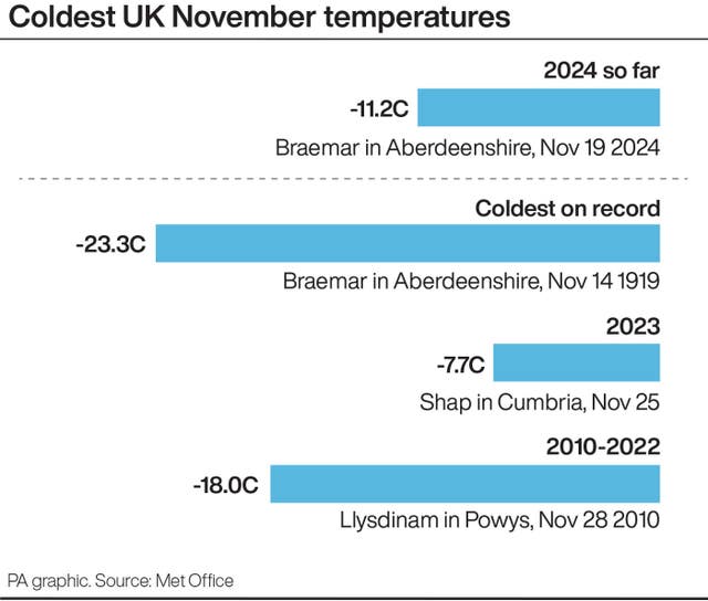
“Overnight temperatures will drop below zero fairly widely over the next few days, which has resulted in some ice warnings, with further warnings likely through this week.
“On Thursday, a mixture of snow, sleet and rain is likely to affect the South West, which could potentially bring disruption. It’s likely high ground in the area will see snow, with a mixture of conditions likely at lower levels.”

Yellow warnings for rain have been issued from Saturday to Sunday morning in south-west England and Wales.
There is already a yellow warning for heavy snow on Saturday followed by a “rapid thaw” and rain on Saturday night in north-east and north-west England, the West Midlands, Yorkshire, and much of Scotland.
Met Office deputy chief meteorologist Dan Holley said: “Storm Bert marks a shift to much milder air and wintry hazards will gradually diminish through the weekend, but heavy snowfall is expected across parts of northern England and Scotland for a time on Saturday, especially over higher ground, and warnings are in place.
“Heavy rain through Saturday and Sunday, especially in southern and western parts of the UK, will also bring impacts for some with a number of warnings in place. We expect 50-75mm of rainfall quite widely within the warning areas, but in excess of 100mm is possible over high ground in parts of Wales and south-west England.
“In addition, rapid melting of lying snow over the weekend and periods of strong winds are likely to exacerbate impacts and bring the potential for travel disruption, as well as flooding for some.”


